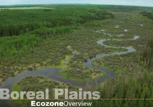
The what Plains?
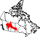
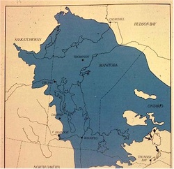
The Boreal Plains are found in the center of Alberta, by which means extend east through the center of Saskatchewan, and slightly south of central Manitoba. In The Boreal Plains ecozone, relief varies from flat land to plains and gently rolling hills, usually found in the west. These plains were formed by continental glaciations in the Ice Age, which left glacial deposits behind.
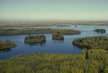
The Boreal Plains ecozone is part of the flat interior plains of Canada and is located in the provinces of Manitoba, Saskatchewan and Alberta in western Canada and also extends slightly into northeastern British Columbia and the south-central Northwest Territories. The subdued relief consists of low-lying valleys and plains stretching across the mid portions of Manitoba and Saskatchewan, and continuing through almost two-thirds of Alberta. It covers 650 000 square kilometres, an area larger than the Yukon. This region has few lakes. However, meltwater from glacial retreat between 11,000 and 8, 000 years ago resulted in extensive deltas and dunes, forming Lake Winnipegosis at the eastern end of this zone. It is a remnant of Lake Agassiz, a large glacial lake
The Boreal Plains ecozone is part of the flat interior plains of Canada and is located in the provinces of Manitoba, Saskatchewan and Alberta in western Canada and also extends slightly into northeastern British Columbia and the south-central Northwest Territories. The subdued relief consists of low-lying valleys and plains stretching across the mid portions of Manitoba and Saskatchewan, and continuing through almost two-thirds of Alberta. It covers 650 000 square kilometres, an area larger than the Yukon. This region has few lakes. However, meltwater from glacial retreat between 11,000 and 8, 000 years ago resulted in extensive deltas and dunes, forming Lake Winnipegosis at the eastern end of this zone. It is a remnant of Lake Agassiz, a large glacial lake
Climate.
Most of the major rivers have their origin in the Rockies. These rivers flow east across the ecozone and are the products of rainfall, snowmelt and glacial runoff at their headwaters. The climate of the Boreal Plains Ecozone is determined by its location in the heart of North America. The Rocky Mountains to the west block moisture-bearing winds from the Pacific. The result is short, warm summers and long, cold winters. The annual precipitation, approximately 450 mm, is greater than the evaporation rate, resulting in surplus moisture of up to 100 mm near the southern edge of the ecozone and up to 300 mm in the northern and foothills regions.
Climate Analysis .
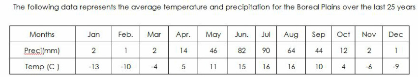
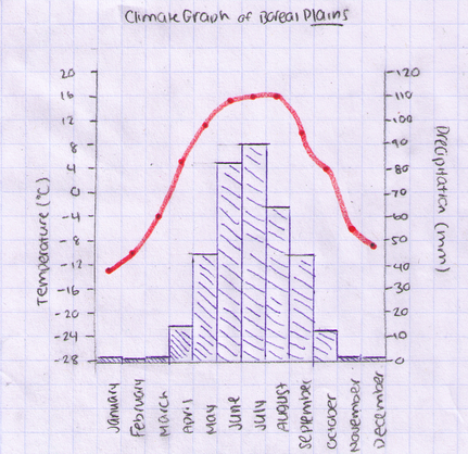
Average Temperature: The average temperature of the Boreal Plains is 2.9 degrees Celsius (approximately 3 degrees Celsius.
Month of Highest Temperature: There are two months in which have the highest temperatures when compared to the rest of the result. This being said, July and August are the months in which have the highest temperatures, both months resulting in 16 degrees Celsius.
Month of Lowest Temperature: The month of the lowest temperature is January, with a temperature of -13 degrees Celsius.
Month of Highest Precipitation: The month of the highest precipitation is July, with an average measurement of 90 mm.
Month of Lowest Precipitation: There are two months in which have the lowest precipitation compared to the rest of the result. This being said, February and December are the months in which have the lowest precipitation, both months resulting in 1 mm of precipitation.
Total annual precipitation: The is 360 mm of precipitation per year.
Geology and Geography.
Numerous ice ages had a distinct outcome on the Boreal
Plains. Continental glaciation flattened the landscape and left behind a diversity
of glacial deposits comprising almost entirely of rolling and level to gently
rolling plains dotted with small lakes. Following glacial retreat 8 000 to 11
000 years ago, larger lakes progressed from glacial meltwater, creating deltas
and dunes.
Water.
There are limited lakes in this region, and outcrops are
scarce. Due to the pollution and human activity in the surrounding area, the
wetlands and rivers have been damaged. Surface water derives from various water
sources; however – the Saskatchewan River, the Beaver River, and a few other rivers
are the region’s main natural suppliers. Deltas and dunes can also be found
here, due to glacial activity.
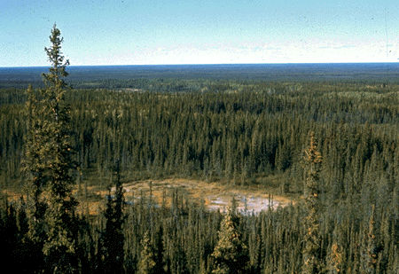
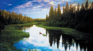
Vegetation and Soil.
The average growing season in the Boreal Plains is 130-165
days long (meaning temperatures above 5 degrees Celsius). It is parkland that forms
a transition between prairie grasslands and boreal forests, and can be categorized
by forest cover such as small stands in moist areas (for example: along
riverbanks and groves). It is also noteworthy to mention that coniferous and
deciduous forests also exist here. Examples of coniferous trees found in the
North include: White Spruce, Black Spruce, Balsam Fir, Jack Pine, and Tamarack,
meanwhile deciduous vegetation comprises of Poplar, Aspen, Balsam, Manitoba
Maples, Trembling Aspens, White Birch, and Eastern Cottonwoods – (which are generally
more located in the South). The Saskatoon berry bush is also a common plant found here.
The region contains extensive marsh areas, and is rather bog-like due to frequent forest fires. 84% of the Plains is covered by timber, with just 20% dedicated to agriculture. However, precipitation and surface and groundwater sources are more than adequate to meet agricultural demand.
The soil in this region is thick and good for tree growth, covering bedrock of the Cretaceous shale. The land is also good for agriculture in its southern areas.
Rocks, rocks, and more rocks.
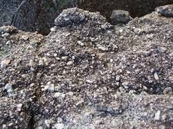
Some of the rocks near bodies of water are well formed by erosion through water and rain, though the process of folding and faulting has created these rocks and the rolling hills. Some of the rocks were not formed by rivers or streams because of the drier climate in the plains. Long ago, while North America was still forming, this region was a shallow inland sea. Sediments from the nearby Canadian Shield and Rocky Mountains slowly accumulated and compressed into sedimentary rock. This being said, best science shows that a very large amount rocks in this region are sedimentary rocks. Moreover, there are tons of oil deposits in this area, thus allowing it to be one of Canada’s main sources of fossil fuels. (Considering that it is rich in clay, and thick organic deposits are common).
Wildlife.
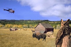
Human activities have separated the original ecosystems of the Boreal Plains into fragments. Because of this, most wildlife populations and their habitats have significantly diminished. Although logging is believed to be partly responsible for an increase in Moose populations since 1955, forest habitat has been lost steadily to timber harvesting. Fish in major rivers and lakes must now face subsistence and commercial fisheries and an array of recreational activities. Within these aquatic ecosystems, there is concern for high-value fish stocks, particularly Walleye, which are sought after by both commercial and recreational fishers. Habitats are also suffering due to the increased water consumption and toxic farm run-off in the surrounding area.
Additionally, wetlands form a vital part of wildlife habitat, often surviving forest fires to provide refuge and initial browsing lands for wildlife.
The most conspicuous local species comprise of the Timber Wolf, Black Bear, Moose, Woodland Caribou, Mule Deer, Elk, and Beaver. Typical bird species are Gray Jay, Common Loon, White-tailed Sparrow, American Redstart, Canada Warbler and Ovenbird. Game birds found in the region include species of grouse, geese, ducks and ptarmigan. Little is known of the insects and arthropod communities.
Research displays that a minimum of four vertebrate species have vanished from the area: the Plains Grizzly, Swift Fox, Black-footed Ferret, and Greater Prairie Chicken. Peregrine Falcon (anatum), Mountain Plover, Eskimo Curlew, Piping Plover, and Whooping Crane are endangered species, and have no vanished from the area – meanwhile, threatened species include the Borrowing Owl and Ferruginous Hawk.
Human versus Land.
This region is sparsely populated since the people who live in this ecozone are scattered in small communities. Today, only about 700 000 people, many of them relatively young, live in the ecozone. Despite rapid urban development over the past two decades, just 40% live in major cities. Most municipalities are relatively small compared with those of the Prairie Ecozone.
Agricultural development has largely transformed the southern and northwestern areas of the ecozone. However, posts along the major rivers at sites such as The Pas and Cumberland House were set up for trading companies and more significantly, fur trade. For the past fifty years oil and gas have been the major economic focus in Alberta. Also, bison was hunted, first for its meat, which was consumed by fur traders in the 1780s, and then for its hides, which were sold to the North American fashion industry. Thousands of bison were killed each year, leading to the virtual elimination of free-roaming bison by the 1880s.
After 1870, when the Hudson's Bay Company surrendered its charter and sold Rupert's Land (which included the entire Boreal Plains Ecozone) to Canada, development greatly increased. Canada encouraged land development to secure the area from potential expansion of the United States. Much of the arable land was occupied in the years following the completion of the transcontinental railway in 1885, which also introduced coal mining. With the settlement of the prairies came demand for lumber. Nearly half the ecozone is occupied by productive forests. Logging was concentrated in the southern fringes and, by 1900, large sawmills were in operation.
Substantial oil and gas reserves were discovered in Alberta in the early 20th century. This has been of great importance for the economy for the last 50 years. In Manitoba and Saskatchewan, meanwhile, several hydro-electric power plants were built.
The most recent major development in the region, is the increased use of forests. Between 1951 and 1991, forest harvests increased by 82%. Agriculture has also become a more visible influence. Farmland has increased by 8% over the last 20 years, but still occupies less than 10% of the Boreal Plains. Agricultural activities are dominated by wheat, pasture and rangeland.
The economic structure of the ecozone reflects a relatively high dependence on the service sector, which employs 65% of the labour force, and the primary industries. Over the past century, much of the ecozone has been put to use harvesting natural resources. Forestry predominates, along with agriculture, oil and gas development, hydro-electric power generation, fisheries and mining. The First Nations of the ecozone are tied tightly to traditional places of spiritual significance and ancient burial grounds. They use the ecozone's forests as both their home and workplace. Wildlife is particularly valuable to those who rely on hunting, trapping, and fishing as a primary source of food.
"Olay Olay, Olay Olay, Feelin' hot, hot, hot!"
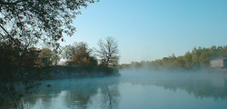
Lake Winnipegosis, Manitoba, Canada.
Lake Winnipegosis a very large lake at approximately 5,370 km² in central North America - located in Manitoba, Canada. The extended, 240 kilometres long lake is the second-largest of three large lakes in central Manitoba; the other two are Lake Winnipeg, the largest, and Lake Manitoba, though it is commonly referred to as Canada's eleventh-largest lake. Lake Winnipegosis also lays on the prehistoric glacial Lake Agassiz. The lake's watershed extends over 49,825 km² in Manitoba and Saskatchewan. The lake drains through the Waterhen River into Lake Manitoba, and is thus part of the Lake Winnipeg, Nelson River, and Hudson Bay watersheds. The lake is known for its significant commercial fishery of walleye and other freshwater species. Northern pike and mullet together now account for over 80 percent of its commercial fishing. It is also recognized for its migratory bird populations. There are several surrounding communities nearby the above mentioned lake, however commonly mentioned communities on the lake include Camperville and Winnipegosis.
Lake Winnipegosis a very large lake at approximately 5,370 km² in central North America - located in Manitoba, Canada. The extended, 240 kilometres long lake is the second-largest of three large lakes in central Manitoba; the other two are Lake Winnipeg, the largest, and Lake Manitoba, though it is commonly referred to as Canada's eleventh-largest lake. Lake Winnipegosis also lays on the prehistoric glacial Lake Agassiz. The lake's watershed extends over 49,825 km² in Manitoba and Saskatchewan. The lake drains through the Waterhen River into Lake Manitoba, and is thus part of the Lake Winnipeg, Nelson River, and Hudson Bay watersheds. The lake is known for its significant commercial fishery of walleye and other freshwater species. Northern pike and mullet together now account for over 80 percent of its commercial fishing. It is also recognized for its migratory bird populations. There are several surrounding communities nearby the above mentioned lake, however commonly mentioned communities on the lake include Camperville and Winnipegosis.
Lake Agassiz, Manitoba, Canada.
The very well-known Glacial Lake Agassiz was formed approximately 11,500 years ago from the massive ice sheet that had previously covered all of Manitoba. Glacial Lake Agassiz played a central role in shaping Manitoba’s topography and human history. At one point in time, Lake Agassiz was once considered larger than any other continent (at its maximum) covering in total more than 500,000 square kilometres of Manitoba, Saskatchewan, Ontario, (Canadian Provinces) and North Dakota and Minnesota (American States).
Whenever the lake stabilized for a period of time, waves created low cliffs and beach ridges which are still visible to present day. This is a result of Lake Agassiz rising and falling numerous times with advances and retreats of the glacier and the opening and closing of various drainage channels.
Elevated and well-drained, these platforms (such as beaches) served as campsites, lookouts for sighting game, burial grounds, travel routes between seasonal camps, and sources of stone to fashion tools.
National Parks.
Four National Parks exist in the region: Elk Island and (most of) Wood Buffalo, in Alberta; Prince Albert, in Saskatchewan; and Riding Mountain, in Manitoba.
Prince Albert National Park, Saskatchewan, Ontario.
Prince Albert National Park protects a slice of the ‘boreal’ forest. It is also a meeting place or transition zone between the parkland and the northern forest. The park features many outstanding natural wonders and cultural treasures, including the only fully protected white pelican nesting colony in Canada, the isolated, lakeside cabin of conservationist Grey Owl and a free-ranging herd of plains bison.
The townsite of Waskesiu, located in the park, provides extensive services for visitors.
